This is the annual Christmas letter sent out to friends. This year it's been so delayed that if the post office is efficient, the letters we mail will arrive sometime between Christmas and New Years!
Merry Christmas 2009
It’s been a busy grand-parenting year! Our first 2009 trip was a drive to Arkansas in our gas-sipping Honda Insight for a New Years visit with George’s daughter Lynne, her husband Blake, and our granddaughter Devin. We went back again the first two weeks in May to be resident grandparents to Devin while her parents Lynne and Blake celebrated their 20th anniversary with an adventure trip to Costa Rica.
Devin is two years old and so is Kaylee, daughter of my son, Mark. Mark and his family live only an hour away, so several times every month throughout the year we are able to visit and have dinner with Mark, his wife Emmie, and grandchildren Dylan and Kaylee.
In February, after Super Bowl weekend, we decided to escape the icy-cold Virginia weather, and packed up the Chinook RV for a dash to the tropical surroundings of Florida. The trouble with that plan, however, was that the cold front followed us all the way to the Florida Keys, and we discovered that while we were dealing with Florida temperatures in the 30’s, in Virginia it had climbed back up to the 50’s! Still, we enjoyed some wonderful bird watching in the Florida Everglades.
In March I dug a monster hole almost six feet deep in the front yard to uncover a break in the water line. We spent a chilly week with friends and family at Emerald Isle beach in North Carolina, enjoying walks on the beach and playing lots of music together in the evenings with harp, recorders, tin whistle, autoharp, banjo ukulele, and hammered dulcimer.
Jane’s artificial knees, put in five years ago, are doing well. After training, she felt strong enough to join me in the annual Monument Avenue 10k, along with almost 33,000 other walkers and runners. Jane walked, I ran; we both finished. After it was over, in a moment of seventy-one year old madness, I signed up for and began training four times a week with the Richmond Marathon Training Team. Extra aerobic exercise was provided in May by digging a monster five foot deep hole to locate a second water main break in the front yard!
With the warm weather and the approach of summer, we enjoyed paddling our recreational kayaks on outings to the James and other Virginia rivers. My stepfather Forrest Keck died in June at age 100, and we spent some time in Oakland, California taking care of affairs and visiting with my relatives. We drove to Redding in northern California for a visit with my son Bruce, who is working on a degree in nursing there. The three of us explored the countryside, and climbed the slopes of Mt. Lassen.
We flew from California to Victoria, British Columbia, the springboard city for several weeks of touring and kayaking on Vancouver Island. First, we made our way with eight friends from Richmond to God’s Pocket on Hurst Island for a week of daily sea-kayaking and hiking on the shores of islands we visited, seeing lots of eagles, other sea and shore birds, porpoises, orcas, and humpback whales. The two of us meandered back south down the island, ending with several days at wonderful Victoria, being hosted by a college friend of Jane’s who lives in Victoria.
In late July we hosted our Kansas City great-nephew Alex. For a week we and Linda, Jane’s sister, delighted in providing East Coast adventures before bringing him with us for an early August beach week at Emerald Isle NC with his grandparents. By now my marathon training runs had increased to over 25 miles a week, and at the end of the month I completed my first half-marathon. We found that the demands of the training ate amazing amounts of time as the mileages increased, but did find time to get out sailing a few times in September in our boat “Starlady” on the Mobjack Bay.
October was busy with a visit in Bedford, VA with French visitors to the Bedford D-Day Memorial, another week at our favorite beachfront cottage in Emerald Isle, and the home stretch of long-run training for George. We co-wrote and presented a planetarium program for the Science Museum of Virginia, one of four we did this year. As November approached, we flew off to Costa Rica for a delightful week with George’s cousin Mary, her husband Bill and several other couples. We went sailing, snorkeling, visited national parks, soaked in mineral-laden hot springs, climbed and rode a zip line through the rain forest before heading back into colder weather.
In mid-November the local NBC station interviewed me as the oldest member of the 1,200 people on the Richmond Marathon Training Team. The marathon was on a cool Saturday morning, and my friend Marilyn popped up next to me on the course several different times, jogging with me for many miles, waving a sign on which she had painted "GO GEORGE GO!" and encouraging onlookers to join the chant! Jane managed to observe my progress from four different vantage points along the marathon route, at one place playing loud cheering on a boom-box. As I crossed the finish line at 6 hours, 2 minutes, and 43 seconds, the TV crew was there to catch the old geezer finishing. That same evening we both danced at the wedding reception of our friends Leslie and Scott. To top off November, my daughter Lynne and I went on a trip to Panama for a week with plane tickets and accommodations I had won in a drawing!
On December 8th we celebrated our 25th wedding anniversary. Friends and family joined us at the James Center downtown to enjoy the Christmas lights, a celebratory dinner, and a Christmas concert. We are planning to spend Christmas Day with 98 year old Aunt Mary Frances and Jane's sister Linda. Then we will fly to Kansas City to visit Andy, Jane’s brother, and his family. A quick trip to see Devin (and of course, her parents) in Arkansas will bring our year to a close.
Best wishes for a wonderful 2010 to you and those you love.
Tuesday, December 22, 2009
Saturday, December 19, 2009
Nor'easter!
It has been years since warm, moist air swept up from the Gulf of Mexico to meet icy air pouring down from Canada to meet over Virginia and dump lots of snow. In Richmond this morning there were 10" on the ground near the James River. The only vehicles moving were trucks and SUV's. I put on cross-country skis and made my way to the top of our hill, about a mile from the house, and enjoyed a nice downhill run back down the middle of Scottview Drive to Riverside. More skiing this afternoon on the trails in James River Park.
Saturday, December 12, 2009
The last few days of Fall
It's beginning to feel more like winter than Fall. More and more nights when the temperature drops below freezing. It's time to be inside with dancing flames in the fireplace and carols playing. It's a time for good food and good wine and good friends.
Saturday, November 28, 2009
Panama - a Trip to Embera Puru -Part II
On our arrival in Embera Puru we were escorted by most of the village up from the river bank and into the meeting house, a large rectangular open sided building with palm thatching.
 The chief and his wife greeted us in Embera, and the shaman translated into Spanish. Anne Gordon de Barrigon our tour guide is married to Otniel, a member of this tribe. She translated the Spanish into English for us as our hosts described life in the village.
This group had lived in the Choco region. About 35 years ago they fled the abuses and bad treatment they were enduring, and came north, through Darien, which includes the southernmost part of Panama and adjacent lands in Colombia, searching for a better place to live. They found it in the rainforest off a branch of the Chagres River, a spot with a high bank above flood level, relatively easy access to more populated areas down stream, plenty of fish, and good hunting in the forest. They were already living there when the government of Panama formed the 500 square mile Chagres National Park in 1985 to protect the watershed that is so essential to the continued operation of the Panama Canal. Water is vital to the function of the canal locks since each boat that crosses the locks needs around 52 million nonrecoverable gallons of fresh water. The Chagres River is dammed downstream from Embera Puru, creating a large reservoir lake that feeds water in Lake Gatun, which in turn functions as a big section of the canal, and provides water for the operation of the locks. The Embera were grandfathered in and allowed to stay on their land, living pretty much as they always have, hunting and fishing, growing a few rainforest crops and harvesting a wide variety of medicinal plants from the surrounding jungle for their own health needs.
 Their homes are built up off the ground about ten feet to keep things dry in a very wet, rainy region and to reduce the risk of snakebite from fer-de-lance, coral snake, and the central american bushmaster, all of whom are very venomous. Access to each house is via a log with steps chopped into it, leaned up against the elevated floor. The springy, resilient floors of the houses are made from the thick flattened bark of a local tree. Under the house is reserved for storage and hanging things to dry.
 The cooking is done above. Each house has a rectangle of small logs near one edge of the floor. Into this has been placed multiple layers of banana leaves, covered with six to eight inches of dirt, providing a place to build a cooking fire on a wooden floor. We were served a delicious lunch of patacones (twice fried green bananas smushed into delicious little crisp yellow patties, and fresh river bass caught that morning. We rinsed our greasy fingers in a bowl of water with crushed basil leaves in it. Refreshing! We finished off the meal with slices of fresh, sweet pineapple and papaya.
We had some time to wander the village wherever we wished. Some of us went back to the meeting house to look at beautiful carvings, lovely decorated baskets woven so tightly that they will hold water, and other handicrafts. I bought a wooden flute like the one I had heard played by the welcoming committee as we first were arriving.
 Another option that Lynne and I both took advantage of was to be decorated with an Emerba-style tattoo. Every member of the village does this. A dye is made from the fruit of the jagua tree. Held in a small coconut shell cup, the purple-grey liquid is applied carefully to the skin with a small forked stick of bamboo, making a double line. The designs are first outlined, and then the tattoo artist uses fingers and hands to fill in solid the space between the designs by applying more of the juice. Lynne chose an open design that looked like a necklace of leaves around her neck, and I opted for the full design on chest, arms, and back down as far as my waist. Since I was wearing long pants instead of a loincloth, I decided to stop there. In addition to being dramatic in design decoration the tattoos also serve as an excellent insect repellent, even though the dye has no particular odor to humans. It is also used for its antiseptic, antibiotic, bactericidal and fungicidal properties, and provides an amazingly effective screen against sunburn. At first the tattoos were very light, but they continued to darken for a couple of days until they turned black. The designs last only about ten days or two weeks at the most before fading away, and as they disappear the Embera renew them with different designs. At least that's what we were TOLD; it remains to be seen how long they last on pale North American skin!
 We took a half hour walk with the village shaman up hills and down hills on a forest trail, clay slick in places, stopping often as he pointed out various plants that are used for a wide variety of treatments that include, headache, indigestion, fever, snakebite, the improvement of birth contractions, erectile disfunction, and antibiotics.
On our return to the village a number of the men and women had assembled in the meeting house, and they invited us in to be entertained with some music and dancing. The men drummed and played flute as the women sang and danced. First was a bird song and second was a jaguar dance. All the women lined up, oldest in front, youngest in the back, and they moved in a line around the room, bent forward and slapping bare feet on the smooth clay dirt floor in a syncopated rhythm as they sang. These two performances were followed by some more music they called a rumba, and we all were invited to participate. Great fun!
 All too soon it was time to leave, and those of us not staying in the village overnight made our way back down to the edge of the river to get back in the big dugout for the long trip back downriver and across the lake to the waiting van. The men of the village gathered again on the high riverbank, playing the flute and drums to say goodbye, and the music faded as we headed downstream.
 The chief and his wife greeted us in Embera, and the shaman translated into Spanish. Anne Gordon de Barrigon our tour guide is married to Otniel, a member of this tribe. She translated the Spanish into English for us as our hosts described life in the village.
 This group had lived in the Choco region. About 35 years ago they fled the abuses and bad treatment they were enduring, and came north, through Darien, which includes the southernmost part of Panama and adjacent lands in Colombia, searching for a better place to live. They found it in the rainforest off a branch of the Chagres River, a spot with a high bank above flood level, relatively easy access to more populated areas down stream, plenty of fish, and good hunting in the forest. They were already living there when the government of Panama formed the 500 square mile Chagres National Park in 1985 to protect the watershed that is so essential to the continued operation of the Panama Canal. Water is vital to the function of the canal locks since each boat that crosses the locks needs around 52 million nonrecoverable gallons of fresh water. The Chagres River is dammed downstream from Embera Puru, creating a large reservoir lake that feeds water in Lake Gatun, which in turn functions as a big section of the canal, and provides water for the operation of the locks. The Embera were grandfathered in and allowed to stay on their land, living pretty much as they always have, hunting and fishing, growing a few rainforest crops and harvesting a wide variety of medicinal plants from the surrounding jungle for their own health needs.
 Their homes are built up off the ground about ten feet to keep things dry in a very wet, rainy region and to reduce the risk of snakebite from fer-de-lance, coral snake, and the central american bushmaster, all of whom are very venomous. Access to each house is via a log with steps chopped into it, leaned up against the elevated floor. The springy, resilient floors of the houses are made from the thick flattened bark of a local tree. Under the house is reserved for storage and hanging things to dry.
  The cooking is done above. Each house has a rectangle of small logs near one edge of the floor. Into this has been placed multiple layers of banana leaves, covered with six to eight inches of dirt, providing a place to build a cooking fire on a wooden floor. We were served a delicious lunch of patacones (twice fried green bananas smushed into delicious little crisp yellow patties, and fresh river bass caught that morning. We rinsed our greasy fingers in a bowl of water with crushed basil leaves in it. Refreshing! We finished off the meal with slices of fresh, sweet pineapple and papaya.
We had some time to wander the village wherever we wished. Some of us went back to the meeting house to look at beautiful carvings, lovely decorated baskets woven so tightly that they will hold water, and other handicrafts. I bought a wooden flute like the one I had heard played by the welcoming committee as we first were arriving.
 Another option that Lynne and I both took advantage of was to be decorated with an Emerba-style tattoo. Every member of the village does this. A dye is made from the fruit of the jagua tree. Held in a small coconut shell cup, the purple-grey liquid is applied carefully to the skin with a small forked stick of bamboo, making a double line. The designs are first outlined, and then the tattoo artist uses fingers and hands to fill in solid the space between the designs by applying more of the juice. Lynne chose an open design that looked like a necklace of leaves around her neck, and I opted for the full design on chest, arms, and back down as far as my waist. Since I was wearing long pants instead of a loincloth, I decided to stop there. In addition to being dramatic in design decoration the tattoos also serve as an excellent insect repellent, even though the dye has no particular odor to humans. It is also used for its antiseptic, antibiotic, bactericidal and fungicidal properties, and provides an amazingly effective screen against sunburn. At first the tattoos were very light, but they continued to darken for a couple of days until they turned black. The designs last only about ten days or two weeks at the most before fading away, and as they disappear the Embera renew them with different designs. At least that's what we were TOLD; it remains to be seen how long they last on pale North American skin!
 We took a half hour walk with the village shaman up hills and down hills on a forest trail, clay slick in places, stopping often as he pointed out various plants that are used for a wide variety of treatments that include, headache, indigestion, fever, snakebite, the improvement of birth contractions, erectile disfunction, and antibiotics.
On our return to the village a number of the men and women had assembled in the meeting house, and they invited us in to be entertained with some music and dancing. The men drummed and played flute as the women sang and danced. First was a bird song and second was a jaguar dance. All the women lined up, oldest in front, youngest in the back, and they moved in a line around the room, bent forward and slapping bare feet on the smooth clay dirt floor in a syncopated rhythm as they sang. These two performances were followed by some more music they called a rumba, and we all were invited to participate. Great fun!
 All too soon it was time to leave, and those of us not staying in the village overnight made our way back down to the edge of the river to get back in the big dugout for the long trip back downriver and across the lake to the waiting van. The men of the village gathered again on the high riverbank, playing the flute and drums to say goodbye, and the music faded as we headed downstream.
Friday, November 27, 2009
Panama - a Trip to Embera Puru -Part I
My daughter Lynne and I traveled in a small van this morning for 40 minutes in the traffic and dirt and noise of this city of about 800,000.
As we left Panama City behind, the roads became less congested but in worse condition, with lots of potholes capable of swallowing half a tire at a single gulp. The high-rise buildings disappeared, replaced by cinder-block one-room tin-roofed houses with trash in the yards to decorate the rusting old cars. If it hadn't been for the bananas and mango trees, I might have thought I was in West Virginia!
The farther we got from the city, the narrower the road became, now muddy and rutted, spanning small streams in deep worn creek beds with crumbling cement bridges that any cautious person would hesitate to walk across. The paving was far behind us as we lurched up clay-slick hills, back tires spinning just a bit faster than we were moving forward. The jungle crowded down to the edge of the road.
 Eventually the van stopped when it couldn't go any farther without going into Lake Alajuela. There was a huge wooden dugout canoe waiting for us, captained by an Embera man wearing a bright blue loincloth and nothing else except his tattoos from neck to knees.
 Ten of us climbed in the boat to sit two abreast, and the canoe backed out onto Lake Alajuela. Swinging around we headed down the miles-long lake at full throttle, the bow throwing up a standing wave higher than the gunwhales. The water was kept out of the canoe (mostly) only by a narrow splash rail. A steady flow of water dribbled over the edges and squirted under pressure from the small cracks near the bow, running down the 35 foot length of the canoe between our feet. It's the rainy season in Panama, and we skimmed along the coffee-with-cream colored muddy water, skirting around floating plants, sticks, and logs. In the dry season the water level is 30 feet lower, and the trip would involve navigating a small stream instead of a lake.
About 40 minutes into the ride the canoe tilted toward the right as we made a sharp turn and slowed to enter a narrow side channel. Negotiating twists and turns past low hanging branches, and ducking under those we couldn't avoid, a few minutes at idle speed brought us to a lovely waterfall that tumbled down over a ragged basalt scarp. We clambered over the sides into shin deep water and waded the remaining hundred feet or so to the pool at the base of the falls.
 It took no additional encouragement for me to plunge into the cool water and swim over for an impromptu shower under the cascade. Refreshed and soggy, we clambered back into the canoe and it backed out the way we had come. A man standing in the bow used a pole to wedge the long canoe first to the left and then the right as a means of steering.
A short run later we left the lake itself and entered the Chagres River. Another fifteen minutes of a tributary brought us to Em-bear-AH PUru, the Embera Village home of about 150 people who continue to live off the land as they always have. They welcome the occasional small group visits arranged by the American wife of one of the Embera men.
 The throaty roar of the outboard motor alerted the people of the village to our arrival long before we actually got there, and there was a group of eight men on the river bank above the landing, drumming and playing a bamboo flute to welcome us. It appeared that the entire population of the village had come down to the water's edge to meet us, the men wearing loincloths that hung to knees in front and covered much less behind. The women wore brightly colored pieces of cloth that reached from waist to just above the knees, and nothing else.
 Men, women, and children all wore purply-black elaborate tattoos with intricate geometrical designs on shoulders, backs, breasts, stomachs, buttocks, and thighs. We soon found out that the tattoos are not permanent, lasting only a week to ten days before they wear away or wash off. They are renewed frequently, both because the designs are pleasing, and because the chemicals in the plants used to draw the designs serve as a very effective bug repellent.
Click here for Part II
As we left Panama City behind, the roads became less congested but in worse condition, with lots of potholes capable of swallowing half a tire at a single gulp. The high-rise buildings disappeared, replaced by cinder-block one-room tin-roofed houses with trash in the yards to decorate the rusting old cars. If it hadn't been for the bananas and mango trees, I might have thought I was in West Virginia!
The farther we got from the city, the narrower the road became, now muddy and rutted, spanning small streams in deep worn creek beds with crumbling cement bridges that any cautious person would hesitate to walk across. The paving was far behind us as we lurched up clay-slick hills, back tires spinning just a bit faster than we were moving forward. The jungle crowded down to the edge of the road.
 Eventually the van stopped when it couldn't go any farther without going into Lake Alajuela. There was a huge wooden dugout canoe waiting for us, captained by an Embera man wearing a bright blue loincloth and nothing else except his tattoos from neck to knees.
 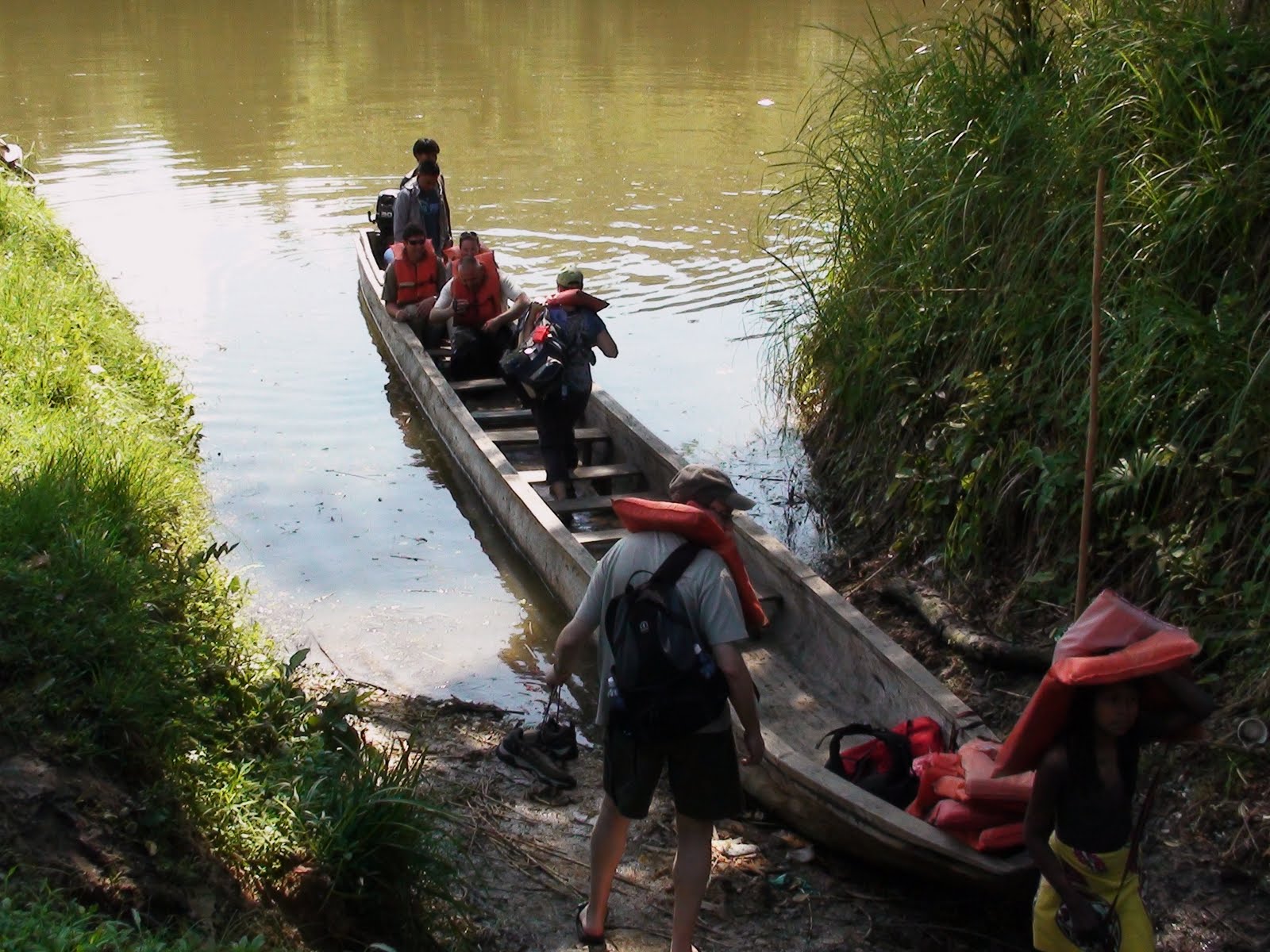 Ten of us climbed in the boat to sit two abreast, and the canoe backed out onto Lake Alajuela. Swinging around we headed down the miles-long lake at full throttle, the bow throwing up a standing wave higher than the gunwhales. The water was kept out of the canoe (mostly) only by a narrow splash rail. A steady flow of water dribbled over the edges and squirted under pressure from the small cracks near the bow, running down the 35 foot length of the canoe between our feet. It's the rainy season in Panama, and we skimmed along the coffee-with-cream colored muddy water, skirting around floating plants, sticks, and logs. In the dry season the water level is 30 feet lower, and the trip would involve navigating a small stream instead of a lake.
About 40 minutes into the ride the canoe tilted toward the right as we made a sharp turn and slowed to enter a narrow side channel. Negotiating twists and turns past low hanging branches, and ducking under those we couldn't avoid, a few minutes at idle speed brought us to a lovely waterfall that tumbled down over a ragged basalt scarp. We clambered over the sides into shin deep water and waded the remaining hundred feet or so to the pool at the base of the falls.
 It took no additional encouragement for me to plunge into the cool water and swim over for an impromptu shower under the cascade. Refreshed and soggy, we clambered back into the canoe and it backed out the way we had come. A man standing in the bow used a pole to wedge the long canoe first to the left and then the right as a means of steering.
A short run later we left the lake itself and entered the Chagres River. Another fifteen minutes of a tributary brought us to Em-bear-AH PUru, the Embera Village home of about 150 people who continue to live off the land as they always have. They welcome the occasional small group visits arranged by the American wife of one of the Embera men.
 The throaty roar of the outboard motor alerted the people of the village to our arrival long before we actually got there, and there was a group of eight men on the river bank above the landing, drumming and playing a bamboo flute to welcome us. It appeared that the entire population of the village had come down to the water's edge to meet us, the men wearing loincloths that hung to knees in front and covered much less behind. The women wore brightly colored pieces of cloth that reached from waist to just above the knees, and nothing else.
 Men, women, and children all wore purply-black elaborate tattoos with intricate geometrical designs on shoulders, backs, breasts, stomachs, buttocks, and thighs. We soon found out that the tattoos are not permanent, lasting only a week to ten days before they wear away or wash off. They are renewed frequently, both because the designs are pleasing, and because the chemicals in the plants used to draw the designs serve as a very effective bug repellent.
 Click here for Part II
Tuesday, November 24, 2009
Panama City - First Impressions
We're here!
I went to bed on Tuesday at about 8:30 p.m. and actually got almost, solid four hours of sleep. I had the alarm set for 12:30, but woke a few minutes early. We were already packed. I had everything stowed in a backpack, since we were headed for the tropics, and it was only for a week. We pulled out of the driveway right on time at 1:00 a.m.
 It rained the whole 120 miles from Richmond to the Dulles Airport west of Washington, D.C. The Copa Airlines ticket counter was open when we entered the terminal, but we had to wait until 4:00 a.m. for the security inspection, so we got bagels at the only food concession open.
The sky was still pitch dark as we cleared the runway at 5:38, and the city lights disappeared immediately in the low, wet overcast. With the cabin lights out it was easy to drift off into the uneasy dozing that masquerades as sleep on an airplane. Somewhere, sometime later, breakfast was announced in Spanish, and we practiced the preying-mantis contortions necessary to cut pieces of food on a miniscule tray without knocking the bite of egg omlette off the fork of the person beside you. High rise buildings admired their own reflections in the waters of Miami Beach as we flew by.
More dozing.....half-watching the featured movie Julia and Julie, and playing with the channels to see how well the audio wizards were able to synchronize English lip movements with Spanish dubbing. Down through the hidden bumps and dips of low-hanging clouds, and onto the runway in Panama City 45 minutes early.
 The cab Lynne arranged was waiting for us, and it was about a 20 minute drive into the city. What a big city it is! There are literally hundreds of very tall, very narrow high rise buildings, with construction cranes all over the place putting up more. We are on the 33rd floor of a high-rise condo with spectacular vistas sloping up gently to the hills behind the city a few kilometers away, and the shoreline of Bahia de Panama. The bay is really nothing more than a slight curved indentation on the Pacific shoreline, and the mud-flat bottom slopes out at such a shallow angle that at low tide the water recedes a quarter to a half mile!
After getting settled we walked about three quarters of a mile to a shopping mall that makes any large mall that I've seen previously look puny by comparison! This mall was easily twice the surface area of any I've seen before, and three stories high. We found the food court and had lunch, then wandered several levels before we found the supermercado (Super Market), where we picked up bread, milk, bananas, and a half papaya. Half a papaya may seem silly until I mention that half of this fruit was a good five inches from center-slice to rind, and about 20 inches long, by far the largest I have ever seen. It will let us eat papaya with lime juice every morning for several days!
 The contrasts here are interesting. It is as if some mischief-maker took a giant stick and stirred and swirled opulent high rise buildings, abandoned factories, modest homes, small old apartment buildings, empty blocks where buildings have been or are being demolished, and tiny one-room tin-roofed houses until they were thoroughly mixed, then sprinkled all with various open-windowed schools throughout for a garnish, the drone of student recitation competing with the constant roar of traffic, horns blaring long blasts to express driver frustration at the congestion.
I need a nap! More later!
Wednesday, November 18, 2009
Richmond Marathon 26.2 miles - I DID it!
 The week before the Richmond Marathon, Joe Sullivan, Sports News Reporter for the NBC-TV Channel 12 in Richmond, called me to say that he had heard that I was the oldest person on the Marathon Training Team, and that he'd like to do an interview.
I met him down on Riverside Drive near my house, and he recorded lots of video footage of me running on the road beside the James River before doing the interview.
The piece aired on the evening news the Tuesday before the race.
An article appeared in the Richmond Times-Dispatch the same day, titled "At 71, Set For Debut"
Better late than never, indeed. George Hastings, a California native who moved to Richmond in 1984, says he has been "in and out of running most of my life He will make his marathon debut on Saturday. At age 71.
Hastings said he has been toying with the idea of running a marathon since he was a teenager. As a 16 year old, he said, he would run from his home to Oakland Technical High School, a distance of about two miles. His goal each day: to try to beat the school bus.
Years passed, and Hastings did much running but never entered a marathon. As his 71st birthday approached, he said, "I thought to myself, 'Good grief! I'm actually getting old. I've been talking about running a marathon for most of my life. It's time to either put up or shut up.'"
He has prepared for Saturday's race as a member of the Marathon Training Team.
The morning arrived. It was time. I had run a short three miles on Thursday the previous week after the TV interview, and had finished with a very sore right knee. A quick visit a few days later to the doctor revealed through an MRI that I had a torn meniscus in my right knee. The doctor, a specialist in sports medicine, said that as long as I took it VERY easy, especially going up or down hills, and wore a neoprene compression sleeve on my knee, that I could attempt the 26.2 miles, with the understanding that my knee kight just lock up, or become so painful that I would have to drop out. After five and a half months of training, I accepted those terms.
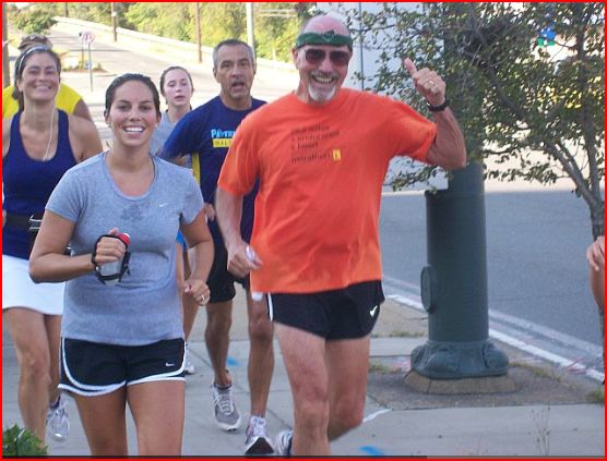
I met other runners gathering a few blocks from the starting line on Richmond's Broad Street, and as we walked the short remaining distance there was excitement and tension. The over 5,000 marathon runners were grouped according to pace per mile, with the fastest of course being in front. The winner was Jynocel Basweti, a man from Kenya, who finished the entire run in 2 hours, 18 minutes, 22 seconds!
I started out deliberately slowly, being extra cautious of my unreliable right knee. Out Broad Street a few miles, jogging a few blocks over to a few miles on Monument Avenue, a few more blocks over for another long stretch on Grove Street, and finally along Cary Street and down a steep hill to the James River. From there, across the Huguenot Bridge and along Riverside Drive. I had a big cheering section of friends and neighbors as I passed the intersection a block from my house, and Jane handed me a most welcome banana to refuel as I left the ten mile mark behind.
From there up a long climb to Forest Hill Drive, and a very long run all the way downtown to the Lee Bridge. Crossing the James River, my running muscles began to tell me, "That's it! We're finished! We're not going to do this any more!", but my brain kept pushing the unwilling mutineers for a few more miles before the muscles won the argument. There were many times I thought that I had reached the point where I would have to stop, but discovered that walking muscles are really quite different than running muscles. I found that I could keep up a brisk pace walking.
 As I came up Main Street I was joined by my friend Marilyn Elder, who ran and walked with me, holding a sign that said, "Go, George, GO!", and exhorting spectators on the sides of the street to join in the chant. It kept me laughing, and my mind off the fatigue and pain I was feeling in my hips by now. It seemed as though there had been no start and would be no end to the run by now. It was just one foot in front of the other, over and over and over. I wasn't out of breath, but the tiredness was building. I crossed Broad Street, and headed into the north side of Richmond in the last six miles, now covering distance I had never done before. My faithful self-appointed coach and publicist Marilyn joined me again as I shuffled my way toward the finish in downtown, dropping out only about a half mile from the finish line.
 A block later I was joined by Chelle Quinn, the head coach of the Orange Team, and she covered the last few blocks with me. As she peeled off about two blocks from the end, I could look down the hill the remaining distance and see the huge crowd watching the stragglers coming in. I was by now the almost the only person on the street, and as I approached the finish line I was propelled onward by a wave of cheering.
 Joe Sullivan from Channel 12 was there, pointing a camera, congratulating me and asking how I felt. Of course I felt wonderful, exhausted, and in pain all at the same time, but mainly elated that I had finished!
You can see the post-marathon show that aired the next day HERE
Training for the Richmond Marathon - 2009
 It has been fun, at 71, being the oldest member out of more than 1,200 people on the Marathon Training Team! We first met at the SportsBackers Stadium in Richmond the first week in June, and the first group run seemed intimidating. It was a total of 4 miles, and by the time I had completed it near the back of the group of about 50 I was running with, I was huffing and puffing.
The following week we were to run on our own 3 miles on Tuesday, 3 miles on Wednesday, and 3 miles on Thursday, getting together with my small training group, the Orange Team, on Saturday to run 5 miles together. Although there were more advanced intermediate groups and I was with the novice group, I discovered on each run that some would take off from the beginning at a brisk pace that they maintained throughout the run. Others like me would start out more slowly, and the Orange Team would rapidly be spread out over great distances, finishing with widely variant times.
Early in the training I attempted to keep up with the fast runners. I discovered quickly that I wasn't able to do that, so I would start out with the fast runners, and cut back to a slower pace partway into the run. I really was paying attention to the time it took me to run a mile, and trying each week to improve the time. For me, that was the wrong approach.
Each week the total mileage increased, and the Saturday group runs became longer too. Each time a longer distance was scheduled, I saw it looming as a goal that I might now be able to achieve.As I look back at the log I kept, I see that the Saturday long runs increased up to 10 miles, then back a bit to 7 the following week, jumping to 12 miles the week after that. Back to 10 miles the next week, and then in mid-July the first half-marathon distance of 13.1 miles. Each time I finished a longer distance I felt elated that I had been able to complete it, but dreaded the next mileage increase.
I was very nervous as I started the official Patrick Henry Half Marathon in Ashland, Virginia in July. I pushed hard for that, and finished the race second in my age group of 70-74 in 2 hours, 38 minutes, and 5 seconds, only about a half hour behind another man in his 70's!
As August, September, and October slid past the running progressed to longer and longer distances, both on the weekday runs and the group runs on Saturdays, building up to a 20 mile run three weeks before the date of the Richmond Marathon.
I finally realized that the average time I took to run a mile was not particularly significant, being that my goal was only to finish the marathon, not to beat anybody. I began to do a better job of setting a deliberately slow pace of not any faster than 13 minutes per mile. I was better able to sustain that pace without "bonking", completely running out of energy near the end of a long run.
The last two weeks before the November 14th Richmond Marathon were planned to taper off on the running intensity to allow muscles and body to recuperate a bit before the big event.
Wednesday, September 30, 2009
Marathon Training
 I'm 71 years old, and I've been in and out of running most of my life.
Mostly out, but I can remember when I was 16 I would run from Oakland Technical High School to downtown Oakland, a distance of about two miles, and try to beat the school bus going the same direction. The bus would pass me with jeering students catcalling out the windows, but then would slow in traffic or stop at a traffic light, and I would pass the bus. Sometime I beat the bus and sometimes it beat me, but it was always a fun challenge. I thought to myself, "Someday, I'll run a marathon!"
After a year of college I entered the Army as a draftee, and of course there was lots of running in training, both during Basic, and later in Germany as a member of the infantry. That wasn't fun, but I can remember thinking to myself, "With all this training, I'll bet I could run a marathon!"
I finished college, got a teaching degree, taught 6th grade in Monterey, California, and after a few years was offered a position as an elementary school principal with a big educational television project in American Samoa. My first assignment was to open a new school on the tiny, mile-wide island of Aunu'u. The school was built on newly cleared land about a mile from the only boat landing. All the school supplies were delivered once a week by motor launch from the harbor at Pago Pago, so on Wednesday mornings I would leave the school office, climb a low sand dune to get a clear view of the ocean to the east to look for supply boat. When I saw it in the distance I would get all the boys from the one eighth grade class, and together we would run along the soft sandy path around the island to the boat landing to offload and carry all the supplies back to the school. I was in wonderful shape, and thought to myself, "If I had more space, I bet I could run a marathon!"
Many years later I lived on another beach when I was working for the educational programs office of the National Aeronautics and Space Administration at the Kennedy Space Center in Florida. I would run for miles in the sand along Cocoa Beach, and think to myself, "I'm strong enough to run a marathon!"
I moved to Richmond in 1984 to teach astronomy and space science at the Mathematics & Science Center, and often would run the four mile loop around the Central Gardens neighborhood during my lunch hour, thinking to myself, "Maybe one of these years I'll run the Richmond Marathon!"
 I first ran the Monument Avenue 10k in 2002, and completed it in only 54 seconds over an hour. I thought to myself, "I bet if I trained I could do it in under an hour!"
The next year I was delighted when I finished in just over 58 minutes.
I became over confident. I didn't train as rigorously the next year. I finished four minutes slower. I thought to myself, "I'd never be able to run a marathon!"
The next year, I didn't even bother to enter the 10 k race.
In 2006 I was diagnosed with prostate cancer, and had a successful prostatectomy. Because I was incontinent as a result of the surgery I thought my days of running were over, but 7 weeks later I managed to run a 5k race while wearing a leg bag. With exercise the problem improved. I was able to get rid of the hardware, but running was still problematic.
The following year I had another surgical procedure which almost completely restored normal bladder function. I completed the the Monument Avenue 10k again, and I thought to myself, "Maybe I could run a marathon!"
I ran another 10k the following year, and although it took me more than an hour, I kept thinking, "I ought to see if I could run a marathon!"
As my 71st birthday approached, I thought to myself, "Good grief, I actually getting old, and I've been talking about running a marathon most of my life! It's time for me to either put up or shut up!"
Ignoring the incredulity of friends, I signed up for the Marathon Training Team. During our first meeting at The Diamond with over a thousand other registrants, I was surprised to hear announced that the youngest participant was 18, and the oldest was 71!....WHOA!...That's ME!
 I'm a proud member of the Orange Team of novice runners, and have been doing the weekly runs on my own and the group runs on Saturday mornings since the beginning of June. This past Saturday I participated in a 16 mile group run, farther than I've ever run before, and when I huffed and puffed back to the starting point I thought to myself, "I really AM going to run a marathon!"
This week is a "slack-off" week: Four miles on Tuesday, eight miles on Wednesday, five miles on Thursday, and a group run on Saturday of 12 miles for a total of 29 miles for the weekThe week of November 5th will be more challenging: 4 miles, 9 miles, 5 miles, and a Saturday run of 18 miles! That will be followed by a slightly less demanding week, and then a week where the Saturday run is 20 miles!
The Richmond Marathon is scheduled for Saturday, November 14th. I WILL finish a marathon!
Wednesday, August 12, 2009
Adventures in British Columbia - July 25th
Saturday, July 25th
In Victoria, B.C. The alarm went off this morning at 5:30, and I bumbled around getting up and dressed in shorts, running shirt and shoes. I put fresh batteries in the GPS, strapped on a water belt, grabbed a cup of coffee with extra sugar from the motel lobby, and was out the front door at 6:06. I’m till hanging in there on the marathon training. From the motel in downtown I ran downhill to the harbor, along the waterfront, past sailboats and fishing boats, floating houseboats, the seaplane dock, and fisherman's wharf, past lots of waterfront condos, and finally out along waterside park trails overlooking the Strait of Juan de Fuca, with the state of Washington and snow capped mountains in the distance. I’m still huffing and puffing on long distance runs, but I’m pleased with my finish time of 1 hour and 48 minutes...right on the 12 minute per mile pace for the whole nine mile route.
After I showered and changed clothes, we ate a big breakfast of potatoes, eggs, bacon, toast, and coffee in the restaurant adjoining the hotel. Gale and Sabra came to pick us up at 9:30. They took us on a meandering tour of Victoria, then back to the motel to pick up the rental car, and we followed them out to the airport to return the car. We all rode together the short distance to Bouchart Gardens, only to find out that the admission price was jacked up today for the fireworks display this evening. We opted to come back on Sunday instead.

The Victoria waterfront is a great place to be on a warm, sunny Saturday afternoon in July! Buscar bands and acts spread themselves arbitrarily along the quay just far enough apart that each could command its own audience. In one spot a group in their teens and early twenties belted out punk rock with considerably more enthusiasm than talent. Farther along a darkly tanned guitarist was singing “Brown-Eyed Girl” along with a Jamaican steel drummer. A comedian/juggler hustled up his own crowd with audience participation schemes, wild antics, and witty patter that kept everyone in his venue laughing.
 The narrow, deeply indented Victoria Harbor is continuously criss-crossed with tiny passenger ferries that are not-too-distant cousins of the little boats we saw herding rafts and logs in the sorting pond at Beaver Cove. Each one of these slightly tippy little aquatic taxis holds a maximum of 10 people. For a few dollars the captain will take you anywhere in the harbor, cheerfully pattering about the shoreline sights, and should you see something you like before your stated destination, will hand you a token good for re-boarding his or any other ferryboat after you’ve strolled around on shore long enough.

We got off at a dock surrounded by thirty or forty houseboats. They lay snuggled together side by side and gently jostling each other in the slight motion of the water. Some were small, single-room affairs, while others were two stories tall, with several rooms, lounging decks with planters, and all the comforts of a real home. Along the wharf there were several food stands, and we enjoyed a couple of overpriced hotdogs on buns before boarding another putt-putting little ferryboat to head back to the hotel.
There was considerable publicity on posters and in guidebooks about the annual “Luminara” festival to be held in a city park that afternoon and evening, but the weather began to look threatening. Just before sunset it began to rain. We waited. Then waited some more. It seemed as though the heaviest rain had slacked off, so we put on rain jackets and started to walk down to the park. We saw lots of wet, bedraggled people heading the other way, many of them herding young children in soggy, drooping costumes.
A paved path led up a wooded slope in the park, and pulsing sounds of music floated down through the dark. Big drops of water dripped from overhanging branches and leaves, and I was thankful for the hooded rain jacket. Several hundred people were in the clearing at the top of the hill where the path emerged from the woods. They were jumping and twisting, arms over heads or holding long skirts up out of the mud, prancing and dancing, or standing on the sidelines clapping or nodding heads while the throbbing rhythms of the Chikoro Marimba Band pounded out through the pouring rain. There were at least five marimbas, the largest of which had deep toned wooden bars eight inches across and a couple of feet long. PVC pipes of different lengths hung underneath, resonating and amplifying the hypnotic beat.
No one seemed to be paying the slightest attention to the rain, which continued to pour down on dancers and musicians alike, and water splashed off the marimba bars as the padded mallets pounded on. The set finally came to an end, and lights on sidewalk stands began to turn off. As the marimbas were being dismantled the crowds of people began to wander off into the dark with smiles on their faces.
In Victoria, B.C. The alarm went off this morning at 5:30, and I bumbled around getting up and dressed in shorts, running shirt and shoes. I put fresh batteries in the GPS, strapped on a water belt, grabbed a cup of coffee with extra sugar from the motel lobby, and was out the front door at 6:06. I’m till hanging in there on the marathon training. From the motel in downtown I ran downhill to the harbor, along the waterfront, past sailboats and fishing boats, floating houseboats, the seaplane dock, and fisherman's wharf, past lots of waterfront condos, and finally out along waterside park trails overlooking the Strait of Juan de Fuca, with the state of Washington and snow capped mountains in the distance. I’m still huffing and puffing on long distance runs, but I’m pleased with my finish time of 1 hour and 48 minutes...right on the 12 minute per mile pace for the whole nine mile route.
After I showered and changed clothes, we ate a big breakfast of potatoes, eggs, bacon, toast, and coffee in the restaurant adjoining the hotel. Gale and Sabra came to pick us up at 9:30. They took us on a meandering tour of Victoria, then back to the motel to pick up the rental car, and we followed them out to the airport to return the car. We all rode together the short distance to Bouchart Gardens, only to find out that the admission price was jacked up today for the fireworks display this evening. We opted to come back on Sunday instead.

The Victoria waterfront is a great place to be on a warm, sunny Saturday afternoon in July! Buscar bands and acts spread themselves arbitrarily along the quay just far enough apart that each could command its own audience. In one spot a group in their teens and early twenties belted out punk rock with considerably more enthusiasm than talent. Farther along a darkly tanned guitarist was singing “Brown-Eyed Girl” along with a Jamaican steel drummer. A comedian/juggler hustled up his own crowd with audience participation schemes, wild antics, and witty patter that kept everyone in his venue laughing.
 The narrow, deeply indented Victoria Harbor is continuously criss-crossed with tiny passenger ferries that are not-too-distant cousins of the little boats we saw herding rafts and logs in the sorting pond at Beaver Cove. Each one of these slightly tippy little aquatic taxis holds a maximum of 10 people. For a few dollars the captain will take you anywhere in the harbor, cheerfully pattering about the shoreline sights, and should you see something you like before your stated destination, will hand you a token good for re-boarding his or any other ferryboat after you’ve strolled around on shore long enough.
We got off at a dock surrounded by thirty or forty houseboats. They lay snuggled together side by side and gently jostling each other in the slight motion of the water. Some were small, single-room affairs, while others were two stories tall, with several rooms, lounging decks with planters, and all the comforts of a real home. Along the wharf there were several food stands, and we enjoyed a couple of overpriced hotdogs on buns before boarding another putt-putting little ferryboat to head back to the hotel.
There was considerable publicity on posters and in guidebooks about the annual “Luminara” festival to be held in a city park that afternoon and evening, but the weather began to look threatening. Just before sunset it began to rain. We waited. Then waited some more. It seemed as though the heaviest rain had slacked off, so we put on rain jackets and started to walk down to the park. We saw lots of wet, bedraggled people heading the other way, many of them herding young children in soggy, drooping costumes.
A paved path led up a wooded slope in the park, and pulsing sounds of music floated down through the dark. Big drops of water dripped from overhanging branches and leaves, and I was thankful for the hooded rain jacket. Several hundred people were in the clearing at the top of the hill where the path emerged from the woods. They were jumping and twisting, arms over heads or holding long skirts up out of the mud, prancing and dancing, or standing on the sidelines clapping or nodding heads while the throbbing rhythms of the Chikoro Marimba Band pounded out through the pouring rain. There were at least five marimbas, the largest of which had deep toned wooden bars eight inches across and a couple of feet long. PVC pipes of different lengths hung underneath, resonating and amplifying the hypnotic beat.
No one seemed to be paying the slightest attention to the rain, which continued to pour down on dancers and musicians alike, and water splashed off the marimba bars as the padded mallets pounded on. The set finally came to an end, and lights on sidewalk stands began to turn off. As the marimbas were being dismantled the crowds of people began to wander off into the dark with smiles on their faces.
Tuesday, August 11, 2009
Adventures in British Coloumbia - July 24th
Friday, July 24th
This morning we drove down Highway 1 from Parksville to Nanaimo, where we explored the old log Bastion, built in the 1850’s by the Hudson Bay Company to protect its coal mining operations here. I marveled at an old map of the mines that showed literally hundreds of tunnels beneath the waters of the harbor. We wandered through the terraces and craft stalls overlooking the marina and harbor before heading south again.
The town of Chemainus, pronounced Chuh-MAIN-us, used to be a prosperous lumbering town before the sawmill shut down. In 1982 the town began to invite artists to paint murals depicting different aspects of the town’s history on buildings around the town. Today there are 39, with several more planned.
We ate lunch in the city park while listening to a Bolivian musician playing flutes and panpipes, and then took a walking tour. We covered the remaining 78 km to Victoria in the afternoon, checked into a motel near the city center, and were hosted for dinner at Gale and Sabra’s house.
Adventures in British Coloumbia - July 23rd
Thursday, July 23rd
Woke up early, and at 7:00 I decided to do my run in the morning instead of the afternoon. I peeked out the door of the motel to find thick fog obscuring everything more than a couple of blocks away. After some stretching I stepped back in to take off my fleece so I wouldn’t overheat, and removed my glasses since they don’t have windshield wipers! The first few minutes of running were chilly with the air at 52 degrees and the wind blowing a fine misty rain, but I warmed up quickly. I ran down the main road two miles toward the edge of Tofino, then back again along the same up and down undulating bike path. When I got back I was delighted to find that I had clicked off four miles in 39 minutes, 30 seconds…better than a 10 minute per mile average…the best I’ve done in a long time.
We went for breakfast at Darwin’s Garden, a botanical garden, then drove south out of Tofino south along the coast. We drove up the steep incline of Radar Hill where there is supposedly a fine view of the surrounding mountains, sounds and islands, but all we saw was thick fog. We parked the car at Long Beach, wedged in between bushes on one side and an enclosed utility trailer, one of several belonging to various surfing instruction companies. A short walk through wind-twisted evergreens brought us to a wide, hard packed sandy beach sloping very gently to the edge of the water almost a quarter mile away. We could just make out many moving black spots looming in the fog at the edge of gently breaking waves. This may be the most popular surfing beach in all of British Columbia. One of the surfers told us that the summer waves, generally 2-3 feet were mostly for beginners, and that the big waves that come roaring in from the northwest on the backs of winter storms bring out the serious surfers.
We drove a little farther to the Wickanannish Beach, where there is an interpretive center. The upper edge of this beach was covered with tumble-worn logs, piled in a jumble that looked like giant pick-up sticks. There were only a few surfers here at the far end of the beach, away from the offshore rocks and the closer in sand bars at this end that create wicked rip currents that sweep rapidly far out from the shoreline. We briefly considered having lunch at a restaurant there, overlooking the surf, but a plain hamburger was $13, and the prices went up from there.
We drove on toward the other oceanside town of Ucluelet (pronounced Oo-CLUE-eh-let). There the meandering hilly streets gave vistas of a small bay and led us to the Canadian Coast Guard station and the Amphitrite Lighthouse on a rocky point at the end of town. We walked down to look at the tidepools and surging surf, and found a nice bench in the warm sunlight that was finally beginning to burn of the morning’s thick fog, and sat there for awhile, listening to the groaning and moaning of a buoy bobbing on the waves a few hundred yards off the end of the point. We made a quick trip back to the car to get lunch materials, and on the way back, I could have sworn I heard the WHOOSH! of a whale’s spout. Soon after, we saw a boat heavily loaded with people, surging and rocking its way across the swells not far from shore, and saw people pointing and calling out to each other. Sure enough, a few seconds later a humpback whale surfaced, took a quick breath, and submerged again. Perhaps 30 seconds later the whale repeated the performance, then again, and one more time before disappearing to stay under for awhile, looking for tasty snacks.
In the late afternoon we started on the sinuous road back across the spine of Vancouver Island. Reaching the east coast, we turned south again and stopped for the evening at Parksville. We had an inexpensive, but delicious dinner at Tim Hortons, dessert at a Dairy Queen, and then drove down to the beach to watch the sunset at 9:15 p.m.
Adventures in British Columbia - July 22nd
Wednesday, July 22nd
We got a leisurely start this morning after a sumptuous gourmet breakfast prepared by Bill and Agathe the Bed & Breakfast hosts.
We drove to Qualicum Beach, where we turned toward the west coast town of Tofino on Highway 4, the Pacific Rim Hwy. We spent a pleasant couple of hours a short distance out of town, exploring the provincial park at Little Qualicum River. There is a narrow, sheer sided rocky gorge here, and impressive waterfalls that plunge down into deep crystal clear pools that reflect back the green of the surrounding forest.
We stopped at Cathedral Grove where there were cedar, spruce, and hemlock trees twelve feet in diameter and as much as eight hundred years old. Nowhere else have I had the same sense of awe that I’ve felt when walking through groves of ancient California redwoods. One of the unexpected differences between these groves and the redwood groves was that the air here smelled like Christmas trees!
We drove on a narrow winding road through towering jagged mountains with patches of snow lingering on the upper rocky slopes. We stopped for a picnic lunch in Port Alberni, then on along more twisting and turning two lane road, pulling off frequently at wide spots to allow the cars piling up behind us to go whisking past. I was reminded of a very different but strangely similar road to Hana in Hawaii. There are two kinds of travelers on both roads: those who take the time to take the curves gently, driving slowly and stopping often to absorb the beauty of the surroundings, and those who take pride in their ability to squeeze every mile per hour out of their cars as they careen around the turns.
Late in the afternoon we drove along the shores of the huge Kennedy Lake and pulled into Tofino. Evergreens crowd the edges of the road and occupy the spaces between buildings. It some ways it is reminiscent of the town of Carmel, California. The air is chilly, and filled with the pungent iodine smell of the kelp beds offshore. Like Carmel, Tofino is an artsy community and a get-away destination for the well-to-do. It is passed around with not too secret pride that John Travolta maintains a place here. There are lots of art galleries and crafts shops, and prices for everything from meals to lodging are exorbitant.
Tofino is also a surfing destination. Wide flat beaches and gentle waves that surfers can ride for long distances attract novices to practice in the summer fog, and professional surfers from all over the world to ride the big storm waves in the winter months. You might even say that Tofino has surfing mania; even the drugstore sells wetsuits!
Adventures in British Columbia - July 21st
Tuesday, July 21st
We got a leisurely start down Highway 19, and at the town of Campbell River turned onto 19A, which runs along the eastern shoreline of Vancouver Island instead of down the middle. We passed through several small waterfront towns, mostly places for vacation homes.
At Buckley Bay we took the ferry across the narrow Straight of Georgia to Denman Island. There is an “almost village” there with a post office and a few craft stores, and not much else. We drove to the north end of the island, and then back down the main road that crosses the island west to east. This connects to a second ferry to Hornby Island, but we opted to explore Boyle Point Provincial Park.
We took about a mile hike through woods to the point on the southern tip of the island. A very narrow channel separates Denman from the tiny Chrome Island and its lighthouse. We barely made it back to the dock in time to catch the 4:30 ferry. We were the last car aboard.
Just a short distance on south down 19A in the town of Fanny Bay we found the Ships Point Bed & Breakfast. The view is spectacular from the deck of this house on a promontory that overlooks the Strait of Georgia and Denman Island. The owners were gracious, but unobtrusive hosts who obviously take great pride in their home and garden.
Adventures in British Columbia - July 20th
Monday, July 20th
I walked up Main Street in Port Hardy past the totem pole at the corner of Hastings to the coffee shop to have French toast while Jane used the motel internet connection. We checked out at 11:00, heading south. On a winding side road that led to the east coast we passed Beaver Cove, a HUGE log sorting operation. An enormous area of the cove was filled with floating logs waiting to be bundled into rafts to be towed to a sawmill. On land, giant front end loaders with big steel claws in place of scoops picked up eight or ten logs at a time, moving them around to different piles according to size. Deformed logs or those that were too short were dumped sideways into the maw of a machine whose spinning innards chewed them quickly into shreds that were carried away along a conveyor belt to some unknown destination. Other machines grabbed the piles of sorted logs, whipping bands around them to tie them into bundles, and trundled them to the edge of the water where they were dumped. Tiny little boats, tipping and rocking alarmingly, their narrow widths and high pilot houses making them look in constant danger of capsizing, scurried around a very large pond, pushing and nudging the groups of logs into larger collections to be rafted together.
A few miles farther we came to Telegraph Cove, an interesting collection of quaint old small houses balanced touching a steep, heavily forested slope and extending mostly out on pilings over the water. Long ago it was a logging camp, then a fishing village. Now it has a marina and a big motel out over the water on the opposite side of the small cove. It provides services for private recreational fishing boats that take advantage of the strong tides through a narrow channel that brings rich nutrients to the surface for the salmon that abound here.
Driving south again on Hwy 19 we pulled off at a rest stop, and discovered a nice woodland trail along the side of a beautiful lake. A short walk down a trail to the water’s edge revealed how quickly the land can recover from clear-cut logging. Pines, spruce, cedar, and alder trees with trunks a foot or more in diameter provided dense shade for ferns and other low bushes that lined a pleasant path that used to be a logging railroad bed.
Another hour’s drive brought us to the little town of Sayward. Driving along a narrow two lane road through scattered houses, we never did find any town center. We continued a way down the road to Kelsey Bay. There IS a discernable village here, set around a green, and just a bit farther, a bay opening into the sound. There WAS a big logging operation here sometime in the not too distant past, but everything is shut down and empty. Very strong winds were whipping up big whitecaps on the channel outside the bay. There were a few boats huddled behind a massive breakwater of large sharp rocks at the left edge of the bay, and several rusting hulks of old ships formed a gloomy looking breakwater on the opposite side. Describe the Cable Cookhouse.
Driving back up the road almost to Hwy 19 we checked into the last available cabin at “The Fisherboy” motel/campground. All the rest of the accommodations were occupied by firefighters who spent each day miles away battling a forest blaze in a box canyon over some distant ridge. They showed up with blackened faces and clothes at around 9 p.m. an hour before sunset, looking pretty exhausted at about the same time I showed up, also exhausted, after running 10k. There was much chuckling, not-very-well-muted commentary, and elbow nudging about my short running shorts on their part as I turned my back to go into the cabin.
Adventures in British Columbia - July 19th
Sunday, July 19th
We woke up early the next morning in Port Hardy, and walked a few blocks down Main Street for some breakfast at the coffee shop. We drove in two cars a few miles south to Port McNeill to meet the whale watching boat.
At the appointed hour we roared off south down the straight at about 40 mph to pick up a family at Hidden Cove, past Alert Bay. When they were safely aboard we hurtled back north again, flying along at full speed past McNeill, Port Hardy, Bell Island, Hurst Island, Balaklava Island, and Scarlet Point out into the Queen Charlotte Straight. Once we reached open water the captain slowed to a stop and turned off the engines. Lowering a hydrophone, he listened in vain for whale sounds.
Dense morning fog hung low over the water, obscuring vision and deadening sounds. The engines rumbled into life again, and the captain proceeded with more caution now, keeping a close eye on the radar screen. He spotted the approaching sailboat several minutes before it loomed out of the fog a few hundred yards off the port bow. Another ten minutes farther out into open water the captain stopped the engines again to listen, but still there were no sounds of whales in the area.
W started slowly back on a course to Port McNeill, and at this point we all thought that it would turn out to be a nice, but expensive boat ride. Fifteen minutes later we spotted the surfacing and spouting of a pod of orcas, and eased over slowly to meet them. The captain stayed the required 100 meters away, and we wallowed along slowly beside them for the better part of an hour. Individual pods of orcas are led by an elder female. Babies born into that pod stay with their mothers for life. Although males will swim with other pods long enough to find a mate and procreate, they always come back to mother. This particular pod was unusual. Several years ago a dying mother orca was found with a severely malnourished baby. The mother died soon after, and rescuers took the baby to be nursed back to health. After more than a year in a large open water pen near the shore the youngster was deemed healthy enough to be released. It soon found a pod to swim with, but wasn’t well tolerated, and soon left. After some time on its own it began to swim with the pod we saw, and was soon adopted into the family. We could see this young whale surfacing along with the others, still not fully grown at age nine.
We got a special treat when one orca swam leisurely under the boat, just a few feet below the surface. We cruised with them for at least an hour before coming back to Port McNeill.
We drove back to Port Hardy where we said goodbye to Jerry, Ruth, John, and Sheila. They headed off to the airport to catch the small plane to Vancouver, where they would stay overnight before their Monday morning flight back to Richmond.
There were festivities that afternoon and evening as people from miles around came into town to celebrate FILOMI Days. FIshing, LOgging, and MIning are the three industries that support the Port Hardy Economy. There was over-amplified rock and country music coming from a portable bandstand that had been parked at the curb next to the waterfront park, a small array of the midway arcade booths you can find at any county fair, face painting for the kids, and an unusual attraction consisting of a twenty-by-twenty foot inflatable pool filled with water and three very large inflatable transparent plastic balls. Kids would climb inside a ball which was then inflated, zipped, and velcroed, then rolled onto the surface of the pond. Big crowds watched with great amusement and the kids tried to stand and walk or run, but mostly fell down inside the floating balls. The crowds began to pack up and head for home when the sun set about 9:00 p.m. and we headed back to the motel.
Adventures in British Columbia - July 18th
Saturday, July 18th
Saturday morning we made one last trip down to the dock, this time hauling our suitcases to be stowed aboard the launch “Hurst Isle” for the trip back to Port Hardy. Once again the day was cool and grey, and the water was an undulant grey mirror that we skimmed across. While our traveling companions dragged luggage up the ramp to the pier I jogged back the four blocks to the motel to pick up the rental car waiting for us in the parking lot.
I transferred luggage to the motel and then took our friends to the Port Hardy airport to pick up a second rental car. We drove in two cars to Port McNeill to catch walk-on ferry to Cormorant Island and the town of Alert Bay.
We ambled along the waterfront street passing a well-used marina occupied by many motorboats and a few sailboats. Several ancient wooden trawlers lolled at odd angles on the rocky beach, most of their paint gone and widening gaps showing between the planks of their hulls. A cedar log at least five feet thick lay in a grass covered empty lot, showing ax-chopped holes where spring boards had been wedged in on opposite sides to provide a place for loggers to stand while sawing down the tree.
Newer cedar logs with the bark carefully removed lay near the First Nations Cultural Center, waiting to be shaped into carved poles honoring the different clans who live here. Completed totem poles had been erected near the entrance to the museum.
After exploring the cultural center we walked up the hill behind it past a decaying old three story brick building that for many years was a residential school where children were placed after being taken from their parents at age six. They were taught to speak English only, and punished if they spoke in their own tongue. By the time they had finished at least six years, it was thought that they would be fully absorbed into proper Canadian culture, and were released. Today the building is being used for offices, and there is a workshop in the basement for indigenous woodcarving.
The Big House, a very large cedar sided meeting center with a low pitched roof built by the First Nations people sits high on a hill behind the harbor. Standing far out in front was the tallest totem pole I have ever seen, probably more than one hundred feet high. The traditional figures of turtle, bear, raven, salmon, eagle, moon, sun were clearly visible on the lower parts of the pole, but it was so tall that it was hard to identify the faces near the top. At the very highest point on the pole sat a real eagle, surveying the world from his lofty perch.
We entered the meeting house through the wide front door. The inside, perhaps sixty feet wide and twice as long, was a single large room with a dirt floor and long tiered benches along each side. Parallel cedar log ridgepoles three feet in diameter spanned the entire length of the room, supporting the rafters of smaller logs. The center of the roof opened into a large rectangular cupola where the smoke from the fire burning in the middle of the room found exit.
We took seats on the side benches, and when a good crowd had gathered the performance began. Flanking the door were two winged totems depicting ravens and at the opposite end of the room two eagle totems kept watch over the single bench that faced the fire. Seated at that bench were several young people whose job it was to sing the tribal chants and keep time by pounding with short heavy sticks on a long hollowed out wooden log drum. Dancers ranging in age from four or five years old to adult demonstrated parts of the ceremonies performed to mark seasons, harvest, and fishing. It was gratifying to see that the language, the culture, and the customs of the people were experiencing a rebirth and growth in the younger people.
Monday, August 10, 2009
Sea Kayaking in British Columbia - July 17th
Friday, July 17th
By now the whole crew considers itself experts, and we demonstrate our group skills as we paddle easily past the end of Balaklava and up Browning Channel all the way past Bob’s Landing, crossing the channel, and passing two small timber covered islands that guard the entrance to Alexander’s Bay, indented deeply into Nigei Island. We haul the kayaks up on a beautiful grey slate shingle beach. There are perhaps 50 feet of flat gravel beach sloping up gently to an immense linear pile of logs and driftwood, funneled into the bay by winter storms.
Immediately behind the barrier of logs is a dense forest that is almost entirely composed of spruce trees. We clambered over the log ramparts and found a trail leading off into the dark, mossy forest. We walked single file about a mile through rain forest with moss so deep and thick that it covered the forest floor like a carpet, covering the ground, the rocks, the trunks and branches of standing trees, and fallen logs and branches the littered the forest floor. The trail, twisting and turning through the jumbled old branches and fallen trees was almost invisible, and it would have been easy to wander astray if it had not been for the ugly old plastic bottles and jugs tied to branches at frequent intervals at eye level.
We emerged from the dark forest into the light at Clam Cove. Across the water was a cluster of ramshackle buildings, and I speculated that it was a tribal village. It wasn’t until later that day that I found out that it was a very run , but still operative dive center. After a brief pause on the shore of the cove, some scurried and others ambled back to the beach at Alexander’s Bay for lunch. By the time we had all regrouped the morning overcast had cleared almost completely, and it was actually hot. I wandered a few hundred yards down the beach and around a huge pile of driftwood, and felt inspired to test the water. It was icy, but refreshing in the heat of the afternoon. After putting my clothes back on and returning, a couple of others also wandered down to that sheltered part of the beach to indulge in the pleasures of skinny dipping.
It was late in the afternoon before we started the long, hard, five mile paddle back to the cabins. As we crossed the last half mile of channel to the dock we must have been a sight. Eight long kayaks moved as a phalanx, sandwiched close together in perfect formation, paddles dipping vigorously, surging ahead of the others a foot or two for mere seconds before the falling back again. We were tired and winded as we hauled the kayaks up on the dock one last time. It was a perfect ending for an adventure filled week.
Sea Kayaking in British Columbia - July 16th
Thursday, July 16th
This misty morning we had a strenuous pull across the Christie Channel and up along the eastern shore of Balaklava. The lighthouse at Scarlett Point came into view as we neared the northern end of the island. It perches on a promontory at the top of steep cliffs close to a small indentation in the shoreline that leads to a cleft in the rock only a few feet wide.
Spanning the gap of the small bay, a thick cable droops its catenary curve toward the kelp floating below, and at the low point, an attached rope with a bulbous float hangs to within 20 feet of the water. High on the lighthouse rocks above a cable and pulley with a winch attached stands ready to be lowered, spider-like to pick up cargo whenever a supply boat stops below.
We string out single file and paddle one by one under the cable lift and through the narrow opening into a small shallow lagoon. Scattered along the wooded shore are old channel marker buoys, a barnacle-encrusted marine railway, several ancient outboard motorboats sleeping on cushions of old tires, and a boardwalk leading up the slope into the trees. We lift the kayaks carefully only a little way onto the rough shore, since the tide is ebbing, and walk along a path into the woods.
Walking in the temperate rainforests of British Columbia you can still believe in magic. The forest floor is springy underfoot where thick layers of moss cushion each step and mute all sound. The grey misty daylight struggles down through branches of close growing cedar and hemlock, and you feel compelled to tiptoe, talking only in soft voices, half-expecting wood-nymphs to peek from behind moss covered tree trunks or to duck behind tangled windfalls.
A short climb brought us to the top of a rocky cliff at the edge of the forest to a view of the wide Queen Charlotte Channel, with other dark islands looming out of the fog in the distance. The breeze off the cold water was chilly, and we turned back into the still woods to make our way down to the lighthouse.
Unlike the United States where virtually all of the lighthouses have been automated, in British Columbia most are still manned. As we strolled out into the cleared area close to the lighthouse we were met by Ivan, the head keeper at Scarlett Point. After serving as an assistant at several other lighthouses he was certified as a head lighthouse keeper, and has been living here for the past seven years in one of two houses on the grounds. The second house is assigned to the assistant lighthouse keeper, who was presently away on vacation for a week.
Ivan obviously loves his job, and took great pleasure in telling us about the operation of the light and its equipment. He said that only a week before he had stood for several hours watching the annual return of hundreds of orcas following the movable feast of salmon that are heading in to spawn in the rivers where they were born.
Deer are frequent visitors, for they enjoy nibbling the acres of grass that cover the grounds. Several, including a doe and very young fawn, wandered along the edges of the grounds, apparently unconcerned about the presence of human visitors.
By the time we had returned to the kayaks the lagoon had drained almost completely, the tidal ebb looking like a rushing mountain stream. Ribbon and leaves of seaweed were now the only cover for rocks that had been underwater when we arrived. Every few seconds, small jets of water shot a foot or two into the air as hidden clams squirted miniature geysers from their siphons. We had to wait a half hour for slack tide to make our escape. When we observed the saltwater river reverse its direction and beginning to flow back into the lagoon we launched our kayaks, and steered a narrow winding route between rocks and through thick kelp to make our way to open water. There were strong winds and following waves at our back as we paddled down the Christie Channel, speeding us on our way back to God’s Pocket, but by the time we had finished dinner the surface was once again as smooth as glass in the low rays of the setting sun.
Bill and Anne, the owners of the God’s Pocket Resort invited the lot of us out for an evening sunset cruise, and we all trooped down to the big motor launch. As the sun disappeared behind the ridges of Nigei Island we spotted a humpback whale spouting in the distance. Bill spun the wheel and headed over to where we had last seen the whale. Everyone was watching on the port side of boat, waiting for it to surface again when there was a loud WHOOSH off to the starboard. The whale had swum directly underneath us and surfaced about 30 yards away with an exhalation of fish-breath!
After the excitement Bill took boat up the channel between Balaklava and the Lucan Islands, along the Browning wall, all the way past Point Scarlet, flashing its beacon in the gathering darkness. By the time we had sped back down the Christie Channel and had tied up again at the dock it was 10:30, and we all headed for bed at the end of a wonderful day.
Sea Kayaking in British Columbia - July 15th
Wednesday, July 15th
There is such an abundance and variety of delicious food each morning at God’s Pocket that I have to restrain myself at breakfast. By now all of us here have bonded as a single group, a team, a crew. We waddle away from the dining room/kitchen cabin to get ready for the day’s activities, and are all reassembled down by the kayaks on the dock at 9:00. This morning Dan turns to the right as we leave the tiny bay to skirt the shoreline of Hurst Island.
We see eagles on the rocks. We see eagles perched high on bare branches of trees overlooking the water. We see eagles in flight. It seems there are eagles everywhere, especially when the salmon are running. Dan, our guide from Sea Kayak Adventures jokingly says that there are so many eagles around that they call them Vancouver Island pigeons.
Around the northern tip of Hurst Island we go, paddling through the edges of great masses of kelp, and we breathe in the pungent but pleasant smell of iodine and salt that floats like invisible fog in the chilly morning air.
Harlequin Bay, named for the harlequin ducks often seen there, cuts at an angle for perhaps a half mile into the eastern shore of Hurst Island. We stop near the head of the bay for a water break and rest before retracing our path back out.
Now heading southeast we reach then southern end of Hurst, and group close together, side by side, to cross the deep, narrow channel between Hurst and Bell Island. The combined effects of strong wind and current in the Christie Channel along the steep rocky edge of Bell Island created a heavy chop that made the going hard until we reached a narrow sheltered passage less than fifty meters across. Suddenly the water was calm in the wind shadow of a small hemlock and cedar covered islet. The still water reflected back the images of the trees on both sides as we coasted along, dipping our paddles quietly. Before long we came to a shingle beach where we hauled the kayaks up on the flat-sided gravel for a lunch break.
A short steep path up the bank behind the beach led to a spot where other kayakers had camped. The thick layer of moss on the forest floor would have provided a soft mattress for anyone lying there looking out and down to the green water of the channel. A lovely boat, with sails loose and slack came softly chuff-chuffing down the passage on diesel power, rounded a bend, and slid out of sight as we made our way back down to a hearty lunch spread out on a camp table by Mike and Dan.
We were a bit anxious as we headed back along the return path, anticipating hard, wet work paddling in the open channel into the wind and choppy waves when we left protected waters. It was a welcome surprise to find that the wind had completely died. All the chop was gone, and our trip back across the passage between Bell and Hurst was no more difficult than paddling on a lake. We could focus less on the process of moving forward and more on our surroundings. We saw more eagles, and while passing through a narrow opening a few yards wide between Hurst and offshore rocks, we spotted a mink scurrying about the tide pools, hustling up some dinner. More than once while we completed the circumnavigation of Hurst Island we saw harbor seals popping up for a quick breath of air and a peek above the surface. Off in the distance the dorsal fin of a Dall’s dolphin broke the still water as we rounded the point of our bay and headed for the dock.
Wednesday, July 29, 2009
Sea Kayaking in British Columbia - July 14th
Tuesday, July 14th
Everyone was on time for a hearty breakfast at 8:00. The kayaks were ready for us to slide into the water at 9:00, and we already felt like old pros as we donned spray skirts and life jackets and helped each other steady each kayak as we scrambled off the low dock into the boats. We got ourselves into formation with Dan at one end and Mike at the other for the paddle west across the Christie Passage to Balaklava Island’s southern end at Nolan Point. We skirted the very small sparsely forested Jerome Island, an old Indian burial ground, more accurately designated a place of the dead. It was the practice of the people who lived here originally to put their dead in cedar boxes on the ground or simply hang the bodies on tree branches and let the ravens take them away.
We strung out in a long line, paddles bobbing, dipping, and dripping as we made our way leisurely toward the northwest between Balaklava and the nearby Lucan Islands. In the Browning Passage vertical rock cliffs drop down deep underwater, and we paddled within a few feet, exclaiming at the sight of sea anemones and brilliantly colored sea stars clinging to the rock wall below us in the clear water. This spot in particular is a destination for scuba divers from all over the world for some of the best cold water diving available anywhere.
Several miles later as mid day approached we landed at a pebble beach called Bob’s Landing, although no one could tell us just who “Bob” was. Beyond the sloping rocky beach we could see two huge logs lying on the bank, bound together with thick strands of rusty steel cable. The cleared land behind was smooth and grassy, sloping gently away from the shore, leveling off, and then slanting down to an old sorting pond where lumbermen had floated their giant logs. Perhaps it was “Bob” who had supervised the building of a big boom rig here that could lift the logs in bundles into the small bay to be towed to some distant sawmill. The lumbering operation had been abandoned for a long time, and thick clusters of tall foxgloves hid the old logging road, showing their brilliant stacks of bell shaped flowers and nodding gently in the breeze.
On our return trip we rounded the southern end of Balaklava and skirted the eastern shore toward the north for awhile before “sandwiching” again for the crossing to Hurst. The tide had turned and was flowing with the strong breeze down Christie Passage. My GPS clocked us at 7+ kph as we made the crossing. We were drifting south about as fast as we were paddling east and our vector brought us to a point a bit beyond the entrance to the bay at God’s Pocket. As we paddled between the slopes of the island and the rock outcropping close to shore the buildings and dock were a welcome sight!
After a change of clothes and a few glasses of nice red wine provided by SKA, Steve got out his guitar. He strummed and sang while I tootled on my tin whistle for awhile on the sunlit deck before another sumptuous dinner.
Sea Kayaking in British Columbia - July 13th
Monday, July 13th
The sun was up at 5:30 a.m., long before we were. We walked a short distance along the waterfront to a local coffee shop for breakfast at 7:30, and back a block to the government dock by 8:00. The 20 foot tide was close to its lowest point, so the metal ramp down to the floating dock was steep. The aluminum hulled 60 foot motor launch Hurst Island was waiting for us. The crew of two plus the twelve passengers made short work of carrying boxes of food, supplies, and personal luggage down to the boat where it was passed from hand to hand aboard and stowed below decks.
By 8:30 the big twin diesel engines were pushing us slowly away from shore, turning the reflections of the shoreline trees and grey overcast sky into undulating green and silver abstract paintings. Once clear of the inner harbor the engine sound rose to a throaty roar and the wind across the open deck increased to gale force as we went ripping across the still surface. Small islands loomed in the distance and scrolled past in rapid succession. The huge propellers slashed the water into a churning turmoil of spray and whirlpools that were quickly sucked into the bubbly wake streaming out behind us, but out to the sides the sea was so calm that it bounced back the grey-silver sky like a pool of cliquid mercury. Float bulbs of kelp we saw bobbing on the surface were easily mistaken for the heads of harbor seals at a distance. The occasional real seals we did see ducked out of sight quickly as the sped closer.
Forty minutes later several bald eagles watched us warily from the tops of spruce trees as we rounded the point at the end of Hurst Island. The engine roar subsided to a low rumbling as the God’s Pocket Bay came into view. The rock walls of the cove drop sharply into the water on one side of the densely forested island. A hundred yards away the other shore slopes more gently toward a tree covered rocky outcrop. Some of the rustic buildings of the resort are perched over the water on pilings the head of u-shaped bay while others cling to the slopes above, connected by boardwalks and steps.
The tide was just starting to flow in, and the ramp connecting the walkways with the floating dock descended to it at a steep angle. Everyone pitched in to unload the supplies and baggage. Boxes of food disappeared into the cook house, and we hauled our suitcases and backpacks to our assigned cabins.
After lunch we gathered on the dock for an introduction to the tandem kayaks, the thick lifejackets with multiple buckles, the spray skirts that keep water out of the openings, and exit strategies to be followed in the unlikely event of a capsize. Dan and Mike, the two guides provided by Sea Kayak Adventures assisted in sliding the kayaks one at a time off platforms that were only a few inches off the surface of the water. Easing down into the kayak’s two openings and checking to make certain that the spray skirts were stretched securely over the rim of each cockpit, one by one we paddled out to cluster at the opening of the bay.
Dan and Mike herded us into a side-by-side line not much more than a paddle length apart and told us to remain in this “sandwich formation” while we crossed the mile-wide
Christie Passage to the next island. In case strong winds or currents moved us up or down the channel at unexpected speeds, this formation would guarantee that we’d stay together as a single group.
We paddled along rocky shores and once in awhile through thick beds of kelp as we skirted the west shore of Balaklava Island. We watched lots of eagles watching us pass while they perched on bare branches keeping an eye out for salmon swimming too close to the surface. Although the air was a chilly 55 degrees I found out quickly that a warm flannel shirt and a windbreaker were way too much clothing! As we approached the Christie Passage on the way back we could see that the wind had picked up quite a bit, raising moderate waves and small whitecaps. Once again back in sandwich formation we all made the crossing without incident, but were very happy to have the spray skirts when small cold splashes sloshed across the tops of our kayaks.
Everyone was happy to have the luxury of hot showers and clean clothes waiting. The sun was hanging just above the ridges of Balaklava and the air was cool so we all crowded into the cozy meeting hut for a few glasses of nice red wine before the dinner bell clanged a summons to a mouth watering dinner of fresh caught salmon in the dining hall.
Sea Kayaking in British Columbia - July 12th
Sunday, July 12th
Kim, who checked us into the motel last night is manning the desk again this morning, but passes off the duty to someone else to drive us in the motel van out to the airport to pick up a rental car. On the way, she entertains us with tales of spending seven months on a fishing trawler modified for pleasure use.
She and her husband cruised from the south end of Vancouver Island up the inside passage all the way to Alaska with no particular destination in mind, stopping in out of the way harbors and villages. She recalled vividly pulling in to one northern anchorage. He husband, a former member of the Canadian Coast Guard, contacted the local Coast Guard station and discussed the weather forecast with them. He was advised that a series of severe storms was sweeping in from the northwest, and that if he didn’t leave immediately there was a very good chance that he’d be stuck there until spring!
The left right away, but the first of the storms caught up with them anyway. The winds reached hurricane force and the seas built until the wave heights were more than twenty feet. Her husband, an experienced seaman stayed at the wheel, and sent her below where she’d be safer. Kate told us that she spent the better part of a day and a night in a lower bunk with her back on the mattress and her hands and feet braced against the wood framing of the bunk above to keep from being tossed and slammed around inside the heaving cabin. She obviously survived to tell the tale and the boat proved itself to be very seaworthy, but she did confess that she and her husband have given up cruising!
 The drive north on Highway #19.Vancouver Island’s main road from Victoria to Port Hardy is a long one. The most spectacular overlook along the way was out across the Seymour Narrows of the Discovery Channel. The distance across the narrow channel is only about 700 yards, and much of the entire tidal flow from the Georgia Straight rushes through here at speeds of up to 20 miles per hour! Ripple Rock used to be submerged only 9 feet below the surface at one point, creating enormous whirlpools over 30 feet in diameter which could, and did swallow whole boats. Over the years 119 boats were lost here, and several unsuccessful attempts were made to dynamite the top off the obstruction. Finally in 1958 tunnels were dug under the seabed and up into the rock and more than 1300 tons of explosive were placed to blow up the rock.
Today the narrows is navigable, but care must still be taken by smaller boats to avoid the still wicked currents and eddies.
There are high mountains in middle of island, a few with patches of snow lingering in late July. Far up the slopes there are large sections where lumber companies have done clear cutting of all the trees. Reseeding has been carried out in those areas, but the result is a patchwork quilt effect of trees of different heights and different shades of green. In places on the steeper flanks of some mountains you can see avalanche paths through forests on steep terrain.
As you approach the north end of Vancouver Island the high rocky mountains give way to foothills with gentler slopes, in some places with second growth forest and in other places covered with older cedar, hemlock, spruce and alder. Port Hardy is a small town with a tripartite industrial base of fishing, logging, and mining.
This far north in July the sun doesn’t dip below the horizon until almost 9:00 p.m. so I had time to go for a three mile run before dinner. The motel was directly across the street from a swath of grass and a narrow rocky beach. Off to the right several piers jutted out into Port Hardy Bay. Rusty fishing boats and a 35 foot long Athabascan cedar wood canoe repeated themselves in the dark slow ripples beneath them. A paved path led along the waterfront and through a small park where tall cedars cast long shadows in the setting sunlight. I jogged slowly uphill through a neighborhood where many residents were out and about, chatting with each other on sidewalks or sitting on front porches. Most of them were First Nations people, the term that now describes better than the word “Indian” the people who have lived here for thousands of years. I saw some beautifully carved totem poles in front of the elementary school and the community center. A bit farther up the hill the pavement stopped and the unpaved one-lane washboard road curved off into the dark woods, so I headed back to the motel and a delicious dinner of cedar planked salmon.
Kim, who checked us into the motel last night is manning the desk again this morning, but passes off the duty to someone else to drive us in the motel van out to the airport to pick up a rental car. On the way, she entertains us with tales of spending seven months on a fishing trawler modified for pleasure use.
She and her husband cruised from the south end of Vancouver Island up the inside passage all the way to Alaska with no particular destination in mind, stopping in out of the way harbors and villages. She recalled vividly pulling in to one northern anchorage. He husband, a former member of the Canadian Coast Guard, contacted the local Coast Guard station and discussed the weather forecast with them. He was advised that a series of severe storms was sweeping in from the northwest, and that if he didn’t leave immediately there was a very good chance that he’d be stuck there until spring!
The left right away, but the first of the storms caught up with them anyway. The winds reached hurricane force and the seas built until the wave heights were more than twenty feet. Her husband, an experienced seaman stayed at the wheel, and sent her below where she’d be safer. Kate told us that she spent the better part of a day and a night in a lower bunk with her back on the mattress and her hands and feet braced against the wood framing of the bunk above to keep from being tossed and slammed around inside the heaving cabin. She obviously survived to tell the tale and the boat proved itself to be very seaworthy, but she did confess that she and her husband have given up cruising!
 The drive north on Highway #19.Vancouver Island’s main road from Victoria to Port Hardy is a long one. The most spectacular overlook along the way was out across the Seymour Narrows of the Discovery Channel. The distance across the narrow channel is only about 700 yards, and much of the entire tidal flow from the Georgia Straight rushes through here at speeds of up to 20 miles per hour! Ripple Rock used to be submerged only 9 feet below the surface at one point, creating enormous whirlpools over 30 feet in diameter which could, and did swallow whole boats. Over the years 119 boats were lost here, and several unsuccessful attempts were made to dynamite the top off the obstruction. Finally in 1958 tunnels were dug under the seabed and up into the rock and more than 1300 tons of explosive were placed to blow up the rock.
 Today the narrows is navigable, but care must still be taken by smaller boats to avoid the still wicked currents and eddies.
There are high mountains in middle of island, a few with patches of snow lingering in late July. Far up the slopes there are large sections where lumber companies have done clear cutting of all the trees. Reseeding has been carried out in those areas, but the result is a patchwork quilt effect of trees of different heights and different shades of green. In places on the steeper flanks of some mountains you can see avalanche paths through forests on steep terrain.
As you approach the north end of Vancouver Island the high rocky mountains give way to foothills with gentler slopes, in some places with second growth forest and in other places covered with older cedar, hemlock, spruce and alder. Port Hardy is a small town with a tripartite industrial base of fishing, logging, and mining.
This far north in July the sun doesn’t dip below the horizon until almost 9:00 p.m. so I had time to go for a three mile run before dinner. The motel was directly across the street from a swath of grass and a narrow rocky beach. Off to the right several piers jutted out into Port Hardy Bay. Rusty fishing boats and a 35 foot long Athabascan cedar wood canoe repeated themselves in the dark slow ripples beneath them. A paved path led along the waterfront and through a small park where tall cedars cast long shadows in the setting sunlight. I jogged slowly uphill through a neighborhood where many residents were out and about, chatting with each other on sidewalks or sitting on front porches. Most of them were First Nations people, the term that now describes better than the word “Indian” the people who have lived here for thousands of years. I saw some beautifully carved totem poles in front of the elementary school and the community center. A bit farther up the hill the pavement stopped and the unpaved one-lane washboard road curved off into the dark woods, so I headed back to the motel and a delicious dinner of cedar planked salmon.
Subscribe to:
Posts (Atom)